Saturday 30 May 2015

Creative Topography: The Global Board Game


 Who owns the South China Sea? This has been a contentious issue and there are quite a few bellicose neighbours who rattle their sabres regularly. In the middle, there are several little islands and archipelagos and it seems that he who owns these, controls the seas.

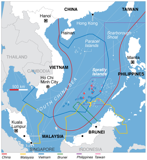
The rules of who owns which bit of water were laid down in the Freedom of The Seas Doctrine after WWII. This was then tweaked by the UN in the early 1980s to create a convention on the Laws of the Seas.


The basic principle was that no-one could own the open oceans but that a nation's territory extended out 12 nautical miles into the sea around their country and its outlying archipelagos (groups of islands). 

Interestingly there is a little loophole which the Chinese are trying to exploit. Article 87 of the UN document says that there are certain 'freedoms' associated with the open oceans: fishing rights, air lanes, submarine cables, etc.. One of these is to 'build an artificial island'.

Now I am sure that at the time the USA was convinced that sneaking this little nugget in meant that they could build military runways and bases around the world should the need arise prior to WWIII. However, the Chinese government have come up with a cunning plan based on a combination of Risk and Reversi: simply build a chain of islands in the open sea and join them up like a huge dot-to-dot puzzle.

According to the UN Convention on Laws of the Seas, you can build islands; and, according to the same document, a nation has rights to the sea surrounding islands and archipelagos which they own.
So logically, if they build new islands, they own the sea surrounding it by right. Simple.

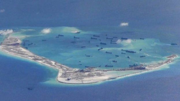
Chinese dredgers building new land in the South China Sea
The Chinese have taken to the task of building new land like a 9 year-old takes to Minecraft. The BBC wrote an article about how they create new land earlier this year.  It is impressive, but it does beg the question: why?
  • Is it to control the fishing rights to the area? 
  • Is it for 'tactical' reasons? Although they are unlikely to invade anywhere and no country in its right mind would think about invading China: it would be like whacking a killer bees nest!
  • Is it because there is oil beneath the seabed?
  • Is it just to annoy the Japanese? 
This latter is probably the most likely reason for the creating of new islands and seeking territorial enlargement. It is very possibly an outmoded display of bluster by a culturally insecure nation, the like of which has not happened in Europe since the Middle Ages ... oh, unless one counts the Ukraine.


Saturday 23 May 2015

Naughty Boy will cause Chaos


Meteorologists around the globe are predicting a major El Niño event next month.

http://www.bbc.co.uk/news/science-environment-32815460 

El Niño is a warming of the Pacific Ocean and occurs on an irregular cycle every 2 to 7 years. "So what?", I hear you cry "we are miles away". Well this is where the interconnectedness of everything comes into play and a series of unfortunate dominos begin to fall. Chaos ensues. 

I have always found the concept of chaos theory quite appealing: the idea that one random change in place A could have disastrous consequences for place B.  Michael Crichton's book, Jurassic Park explains the concept well (http://jurassicpark.wikia.com/wiki/Chaos_theory): the film less so (http://youtu.be/n-mpifTiPV4). 

One slight change in ocean temperature in one part of the Pacific Ocean can cause a ripple of changes throughout our oceans and atmosphere: everything is linked. Whenever there is an El Niño, global weather patterns change: places which should get rain go dry and arid areas get deluged leading to flash floods and hillsides being washed away. As well spoiling our summer, this can have disastrous consequences on LICs which are dependant upon farming, whether for subsistence or economic gain. If the monsoon rains do not arrive and the rice crop in India fails, what impact will this have on world rice prices? Yes, your bag of Tilda from Waitrose will go up by 50p and your takeaway curry might creep up in price. 

In fact, in November last year (right in the middle of the graph) rice prices did jump and buying a kilogram bag of Tilda went up nearly a pound here in the UK. I was outraged at the time as we do tend to consume rather a lot of it. But we can cope with spending an extra few pence a month on food. What about Asian LICs? How will the poorest people on less than a dollar a day afford their staple food? 

In 2010, excessive rainfall in the onion producing parts of India led to a delay in onions getting to market and the "Onion Crisis" led to public outcry in India and political tensions at the highest levels. (http://en.m.wikipedia.org/wiki/2010_Indian_onion_crisis

If you look at countries whose economies are dependant upon selling one or two key crops (sugar, bananas, coffee, etc.) the 'rice scenario' can be applied when El Niño occurs. Millions of people will be affected.

This story will develop over the next few weeks: there will be unusual weather events, flooding, drought and economic disasters. All because of a naughty little boy: El Niño! He will affect weather in the UK to a degree but quite how is difficult to predict. 

Watch this space...

To find out more about El Niño ...


Friday 22 May 2015

Kent Quakes


At 2:52 am, Sandwich shook ... well trembled a bit. This 4.2 earthquake is one of the largest to hit the UK in recent times and most of us slept through it!


Links:

   
Dover experienced some real structural damage
In other locations, the damage was much more serious ...


Sunday 10 May 2015

Exciting Orogenous Zones!

The disastrous quake that struck Nepal a couple of weeks ago has provided scientists with a wealth of data from a variety of different sources.
Seismological data from the global network of sensors can give a lot if information about where, when, how strong and how deep the focus of the quake was. Also, we can look at records and look for trends: often large faults behave a bit like stuck geological zips, unfastening in fits and starts along their length. This data can give us an insight into where and how big a future quake might be, but predicting when it is going to happen is little more than an onformed guess: you'd be better off asking Paul the octopus who predicted World Cup results a whole back. Interestingly, many ancient beliefs around the world refered to unusual animal behaviours as being warnings to imminent tectonic events. I digress. The seismological data cannot tell geologists how the crust has moved and been deformed. This information is vital if we are to understand the forces in action. Satellite's can now measure relief to an accuracy of a centimetre or so. And so, when there is an event like the Nepalese quake, they can map how much the surface has shifted. Hence the map below:
This shows that a significant chunk of the  Himalayas have gone up and another swathe, including Mount Everest, has slumped. This does cause a couple of issues:
1: all relief, previously considered a constant, on maps is out of date!
2: Is Everest the tallest peak? Has another peak outgrown it?

Link to BBC article:
Himalayan 'drop after Nepal quake'
http://www.bbc.co.uk/news/science-environment-32625431 

Saturday 9 May 2015

Nepal Quake mapping problems

Watch this issue of BBC Click ... The ten minutes in the middle are very useful.
How do remote regions in LICs get mapped? How can quake damage be monitored?

http://www.bbc.co.uk/programmes/b05v44pz 

Share and enjoy!